ArcGIS Feature Services: Common Issues, Tips and Effective Solutions
Heads-up: This post may differ from the usual OpSec content. It’s part of my GeoTech Logbook Series, centered around GIS insights where I explore and document practical GIS challenges and lessons.
Introduction
ArcGIS Feature Services play a critical role in enabling dynamic, editable web maps and applications by serving geographic data over the web. However, managing these services in ArcGIS Enterprise or ArcGIS Online can present challenges especially when errors prevent publishing, accessing, or interacting with features.
This guide aims to break down common issues, provide actionable troubleshooting steps, and highlight best practices to ensure smooth operation of Feature Services in any GIS environment.
Understanding ArcGIS Feature Services
ArcGIS Feature Services allow you to publish, query, and edit spatial datasets via web services. These services are commonly consumed in ArcGIS Online, Portal for Enterprise, ArcGIS Pro, and custom web apps using the ArcGIS API for JavaScript or REST API.
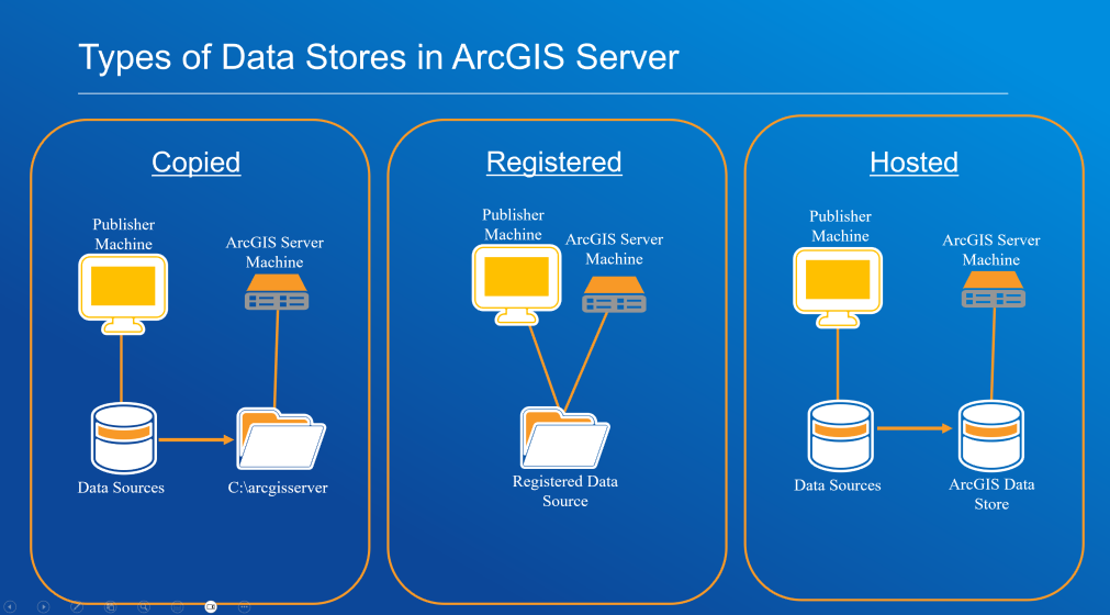
Feature Services can be hosted (stored in ArcGIS Online or Portal), referenced (pointing to existing enterprise geodatabases), or copied.
Common scenarios involving Feature Services:
- Publishing editable layers from ArcGIS Pro
- Syncing offline field data from mobile apps (Field Maps)
- Performing spatial queries from a web dashboard
- Enabling real-time data editing and collaboration among multiple users
- Providing data for custom widgets in Experience Builder or WebApp Builder
- Supporting print and export functions in web mapping applications
Service-Type Specific Guidance
Note: Every ArcGIS Enterprise deployment is different. Troubleshooting steps may not always yield the same results. Always investigate systematically and tailor solutions to your specific environment.
Copied Data Stores
When dealing with copied data stores, the data is copied from the publisher’s machine to the ArcGIS Server machine. Typically used when the source data is not directly accessible to the server.
Key Considerations:
- Data synchronization: Updates to the source data won’t be reflected unless republished.
- Storage management: Large datasets can quickly fill server storage.
- Permissions: Publisher account must have write access to the server directory.
Remediation Checklist:
- Check that data is being copied to the correct server directory.
- Validate data connections, sometimes publishing tools appear to use the correct connection, but the server doesn’t recognize it as registered.
- Analyze ArcGIS Server and ArcGIS Pro logs for publishing errors, job IDs may reveal useful details.
- Check for duplicate data causing confusion or performance issues.
Registered (Referenced) Data Stores
Data remains in its original location (enterprise geodatabase, shared network folder). ArcGIS Server is registered to access the data source directly.
Elements to Consider:
- Data availability: If the data source is offline, services will fail.
- Permissions: Both the publisher and ArcGIS Server account must have appropriate read/write access.
- Performance: Distinguishing between network/database interference and feature service issues can be challenging.
Troubleshooting Steps:
- Confirm the data source is properly registered with ArcGIS Server.
- Validate connection properties, especially for enterprise geodatabases.
- Test data accessibility from the ArcGIS Server machine.
- Review server logs for permission, access, or network errors.
Hosted Data Stores
Data is managed by ArcGIS Data Store (relational, tile cache, or spatiotemporal), supporting hosted feature, tile, or scene layers in Portal for ArcGIS.
Important Factors:
- High availability: For critical services, configure highly available ArcGIS Server and Data Store setups.
- Data backup: Ensure regular backups of the ArcGIS Data Store.
- Security: Properly configure SSL certificates, Web Adaptors, and all security components.
Resolution Steps:
- Check Data Store health via ArcGIS Server and Portal admin interfaces.
- Restart services in the correct order. Portal → ArcGIS Server → Data Store, this is also known as the sequential restart. Do this after working hours in production environments.
- Validate that the ArcGIS License Manager is running and licenses are current.
- Check for recent changes: system restores, version upgrades, or server migrations can disrupt connections.
- Apply relevant patches for known issues.
- Analyze logs for service publishing, data store connectivity, or authentication errors.
Error Lookup: Common Feature Service Issues
- Error 1 → Creating Map Failed - Knowledge Article 000031842
- Error 2 → An Error Occurred Loading This Layer - Knowledge Article 000028732
- Error 3 → Failed to Create the Service - Knowledge Article 000016577
Other Relevant Tips:
- Database locks: Disconnect users or restart services to release locks.
- Max record count exceeded: Adjust
maxRecordCountin service configuration. - Firewall or proxy blocking traffic: Confirm port access and SSL configurations with your IT team.
- Sharing Level: Wrong sharing level (owner instead of organization/public) can lead to inaccessible services and hours of frustration.
- Token expiration: Refresh credentials or configure long-lived tokens for enterprise apps.
Best Practices for Reliable ArcGIS Feature Services
- Regularly validate data in ArcGIS Pro using “Check Geometry” and “Repair Geometry” before publishing.
- Use consistent spatial references across layers in a map document.
- Follow naming conventions and avoid special characters in service names.
- Monitor service health via ArcGIS Server Manager or Portal logs.
- Enable service capabilities (sync, query, editing) based on use-case only and avoid enabling unnecessary features.
- Limit layer size, consider tiling or generalizing large datasets before publishing.
- Enable versioning for enterprise geodatabases when editing is needed.
- Test service endpoints using the REST URL before embedding in apps.
- Use groups and item sharing strategically in Portal or AGOL to manage access securely.
Conclusion
Troubleshooting ArcGIS Feature Services requires a mix of GIS knowledge, system awareness, and familiarity with Esri tools and architecture. Most common issues stem from misconfigurations, unsupported data, or permission conflicts. Applying best practices and learning from common errors greatly enhances the reliability and performance of your ArcGIS environment.
⚠️ Per Esri’s copyright policy, information included here is shared for educational and non-commercial purposes only.
References & Further Reading
- Esri Troubleshooting Feature Services
- Feature Service Publishing Options
- Difference between map service, feature service, and hosted feature layer
“The application of GIS is limited only by the imagination of those who use it.” — Jack Dangermond